Área de identidad
Código de referencia
BR MT INTERMAT 200.221.221.5.221.5.3.INTERMAT 013.078
Título
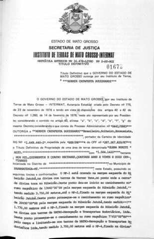
NÚMERO DO TÍTULO: 01672
Fecha(s)
- 26/01/1984 (Creación)
Nivel de descripción
Parte
Volumen y soporte
NÚMERO DA FOLHA: 078
Área de contexto
Nombre del productor
Historia biográfica
Institución archivística
Historia archivística
Origen del ingreso o transferencia
Área de contenido y estructura
Alcance y contenido
- ÓRGÃO DE TITULAÇÃO: INSTITUTO DE TERRAS DE MATO GROSSO
- NÚMERO PROCESSO: 0641/0883
- NÚMERO DO TÍTULO: 01672
- DATA DE EXPEDIÇÃO: 26/01/1984
- NOME DO LIVRO: FUNDIARIO INTERMAT 013
- NÚMERO DA FOLHA: 078
- BENEFICIÁRIO(S)
7.1.1 NOME 01: ADEMIR CATAFESTA SGUISSARDI
7.1.2 CPF 01: 287.267.829-87 - LOCALIZADOR: SEM DADOS
- DENOMINAÇÃO: GLEBA BURITI
- NOME DO ASSENTAMENTO/LOTEAMENTO/GLEBA: GLEBA BURITI
- ÁREA: 1.504.1422 HA
- CONFRONTANTES:
12.1. CONFRONTANTE 01: SEM DADOS
12.2. CONFRONTANTE 02: SEM DADOS
12.3. CONFRONTANTE 03: SEM DADOS
12.4. CONFRONTANTE 04: SEM DADOS
12.5. SITUAÇÃO DOS MARCOS: O MP-1 ESTÁ CRAVADO NA MARGEM ESQUERDA DO RIBEIRAO JATOBÁ, NA DIVISA COM TERRAS DE WERNER YENS, NO PONTO ONDE CERCA D DIVISA TOCA NO RIBEIRÃO. DESTE PONTO DEU-SE INICIO AO CAMINHAMENTO NO RUMO MAGNÉTICO DE 13°40’00’SW PELA MARGEM ESQUERDA DO RIBEIRÃO JATOBÁ, TENDO MEDIDO 3.750,00M, ATÉ O MP-2, FIXADO NA MARGEM ESQUEDA DO RIBEIRÃO JATOBÁ. DESTE PONTO PROSSEGUE-SE AO CAMINHAMENTO NO RUMO MAGNÉTICO DE 20°30’00’’SE PELA MARGEM ESQUERDA DO RIBEIRÃO JATOBÁ, TENDO MEDIDO 1.770,00M ATÉ O MP3, DIXADO NA MARGEM ESQUERDA DO RIBEIRÃO JATOBÁ, NA DIVISA COM TERRAS DE NATRO NAVEGAÇÃO E TRANSPORTES RODOVIÁRIOS, LTDA. DESTE PONTO PROSSEGUE-SE O CAMINHAMENTO NO RUMO MAGNÉTICO 77°10’00’’NW PELO CAMPO E LIMITANDO-SE COM TERRAS DE NATRO NAVEGAÇÃO E TRANSPORTES RODÓVIARIOS LTDA, TENDO MEDIDO 3.700,00M ATÉ O MP-4, FIXADO NA DIVISA COM CLÁUDIO E BUBLITZ. DESTE PONTO PROSSEGUE-SE O CAMINHAMENTO NO RUMO MAGNÉTICO DE 13°54’00’’NE PELO CAMPO E MARGEANDO A CERCA DA DIVISA COM CLÁUDIO E. BUBLITZ, TENDO MEDIDO 4.790,00M, ATÉ O MP-5 FIXADO NA DIVISA COM TERRAS DE WERNERYENS. DESTE PONTO PROSSEGUE-SE O CAMINHAMENTO NO RUMO MAGNÉTICO DE 82°55’00’’SE MARGEANDO A CERCA DE DIVISA COM WERNER YENS, TENDO MEDIDO 2.712,00M ATÉ O MP-1 DA PARTIDA, PONTO ONDE TEVE INICIO ESTE CAMINHAMENTO. PONTO DE AMARRAÇÃO: O PONTO DE AMARRAÇÃO, ESTÁ SITUADO NA BARRA DO CÓRREGO DUVIDOSO COM O RIBEIRÃO DIGO, RIBEIRÃO JATBBÁ, SENDO COMUM AO MP 2. O MP2 POSSUE AS SEGUNTES COORDENADAS GEOGRÁFICAS APROXIMADAS: PARALELO 14°05’40’’ S E MERIDIANO: 54°14’43’’WGR. - MATRICULA Nº: 16.478-LIVRO Nº 2 AY-RGI
- TIPO (RURAL, URBANO): RURAL
- MUNICÍPIO(S)
15.1 MUNICIPIO 01: PARANATINGA
Valorización, destrucción y programación
Acumulaciones
Sistema de arreglo
Área de condiciones de acceso y uso
Condiciones de acceso
Condiciones
Idioma del material
- portugués