Identity area
Reference code
BR MT INTERMAT 200.221.221.5.221.5.3.INTERMAT 018.053
Title
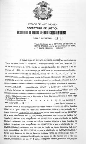
NÚMERO DO TÍTULO: 02148
Date(s)
- 25/10/1984 (Creation)
Level of description
Parte
Extent and medium
NÚMERO DA FOLHA: 053
Context area
Name of creator
Biographical history
Repository
Archival history
Immediate source of acquisition or transfer
Content and structure area
Scope and content
- ÓRGÃO DE TITULAÇÃO: INSTITUTO DE TERRAS DE MATO GROSSO
- NÚMERO PROCESSO: 5443/2027/80
- NÚMERO DO TÍTULO: 02148
- DATA DE EXPEDIÇÃO: 25/10/1984
- NOME DO LIVRO: FUNDIARIO INTERMAT 018
- NÚMERO DA FOLHA: 053
- BENEFICIÁRIO(S)
7.1.1 NOME 01: CECIL MOREIRA RIBEIRO
7.1.2 CPF 01: 013.509.278-72 - LOCALIZADOR: SEM DADOS
- DENOMINAÇÃO: GLEBA SITA ERÊ
- NOME DO ASSENTAMENTO/LOTEAMENTO/GLEBA: GLEBA SITA ERÊ
- ÁREA: 2.499,9904HA
- CONFRONTANTES:
12.1. CONFRONTANTE 01: NORTE: MARIA TEREZA R. DIAS,
12.2. CONFRONTANTE 02: SUL: CÉLIO MOREIRA RIBEIRO E CYRO MOREIRA RIBEIRO,
12.3. CONFRONTANTE 03: LESTE: RUFINO M. MORELO,
12.4. CONFRONTANTE 04: OESTE: PAULO DE SPUZA CARDOZO,
12.5. SITUAÇÃO DOS MARCOS: 1. 2: COM RUMO MAGNÉTICO DE 08°47’30’’SE E COM DISTÂNCIA DE 10.00,00M, LIMITANDO COM TERRAS DE RUFINO M. MORELO, 2.3: COM RUMO MAGNÉTICO DE 81°12’30’’SW E COM DISTÂNCIA DE 2.500,00M, LIMITANDO COM TERRAS DE CÉLIO MOREIRA RIBEIRO E CYRO MOREIRA RIBEIRO, 3.4: COM RUMO MAGNÉTICO DE 08°47’30’’NW E COM A DISTÂNCIA DE 10.000,00M, LIMITANDO COM TERRAS DE PAULO DE SOUZA CARDOZO, 4.1: COM RUMO MAGNÉTICO DE 81°12’30’’SE E COM A DISTÂNCIA DE 2.500,00M, LIMITANDO COM TERRAS DE MARIA TEREZA R. DIAS. PONTO DE AMARRAÇÃO: O LOTE TEM O PONTO DE AMARRAÇÃO, SITUADO NA BARRA DO RIO BRANCO COM O RIO ROOSELVENT, AMARRANDO-SE AO MP 1 PELA POLIGONAL ABERTA, PARTINDO MP1, SEGUE AO RUMO VERDADEIRO DE S 00°00’N MEDINDO 20.000,00M, ATÉ A 1ª ESTAÇÃO, DAÍ SEGUE NO RUMO VERDADEIRO W 90°00’E TENDO MEDIDO 52.456,00M, ATÉ O PONTO DE AMARRAÇÃO. POSIÇÃO GEOGRÁFICA DO MP1: 09°48’32’’S 61°07’44’’WGR. - MATRICULA Nº: SEM DADOS
- TIPO (RURAL, URBANO): RURAL
- MUNICÍPIO(S)
15.1 MUNICIPIO 01: ARIPUANÃ
Appraisal, destruction and scheduling
Accruals
System of arrangement
Conditions of access and use area
Conditions governing access
Conditions governing reproduction
Language of material
- Portuguese