Identity area
Reference code
BR MT INTERMAT 200.221.221.5.221.5.3.INTERMAT 048.099
Title
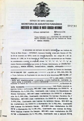
NÚMERO DO TÍTULO: 001154
Date(s)
- 04/03/1987 (Creation)
Level of description
Parte
Extent and medium
NÚMERO DA FOLHA: 099
Context area
Name of creator
Biographical history
Repository
Archival history
Immediate source of acquisition or transfer
Content and structure area
Scope and content
- ÓRGÃO DE TITULAÇÃO: INSTITUTO DE TERRAS DE MATO GROSSO
- NÚMERO PROCESSO: 20188/313
- NÚMERO DO TÍTULO: 001154
- DATA DE EXPEDIÇÃO: 04/03/1987
- NOME DO LIVRO: FUNDIARIO INTERMAT 048
- NÚMERO DA FOLHA: 099
- BENEFICIÁRIO(S)
7.1.1 NOME 01: MUNIR FEGURI
7.1.2 CPF 01: 001.941.901-53 - LOCALIZADOR: SEM DADOS
- DENOMINAÇÃO: SEM DADOS GLEBA BRAÇÃO
- NOME DO ASSENTAMENTO/LOTEAMENTO/GLEBA: GLEBA BRAÇÃO
- ÁREA: 2.499,9999 HA
- CONFRONTANTES:
12.1. CONFRONTANTE 01: NORTE COM TERRAS DE ESPERANÇA DE SOUZA CARVALHO,
12.2. CONFRONTANTE 02: SUL COM TERRAS DE ANTONIO GOMES E BENEDITO CARLOS FERRAZ DE CAMPOS,
12.3. CONFRONTANTE 03: LESTE COM TERAS DE LUCENY JUCELIA DE CARVALHO E ANTONIO GOMES,
12.4. CONFRONTANTE 04: OESTE COM A MARGEM DIREITA DO RIOJURUENA.
12.5. SITUAÇÃO DOS MARCOS: PONTO DE AMARRAÇÃO: PARTINDO DA CONFLUÊNCIA DO RIO SÃO TOMÉ COM O RIO JURENA COM AS SEGUINTES RUMOS VERDADEIROS NE 09°00’SW E N 00°00’S E RESPECTIVAS DISTÂNCIAS DE 21.400,00M E 7.200,00M, ATÉ ENCONTRAR O MPII DO LOTE. COORDENADAS GEOGRÁFICAS DO MPII: 8°23’50’’S/ 58°18’55’’WGR, MP1-MP2: RUMO VERDADEIRO DE 90°00’E E DISTÂNCIA DE 4.916,00M, LIMITANDO COM TERRAS DE ESPERANÇA DE SOUZA CARVALHO, MP2-MP3: RUMO VERDADEIRO DE 00°00’S E DISTÂNCIA DE 2.800,00M, LIMITANDO COM TERRAS DE LUCENY JUCELIA DE CARVALHO, MP3-MP4: RUMO VERDADEIRO DE 90°00’W E DISTÂNCIA DE 5.000,00M, LIMITANDO COM TERRAS DE ANTONIO GOMES, MP4-MP5: RUMO VERDADEIRO DE 00°00’S E DISTÂNCIA DE 3.000,00, LIMITANDO COM TERRAS DE ANTONIO GOMES, MP5-MP6: RUMO VERDADEIRO DE 90°00’W E DISTÂNCIA DE 3.450,00, LIMITANDO COMO TERRAS DE BENEDITO CARLOS FERRAZ DE CAMPOS, MP6-MP1: RUMO VERDADEIRO DE 31°21’NE E DISTÂNCIA DE 6.791,84M, LIMITANDO COM A MARGEM DIREITA DO RIO JURENA. - MATRICULA Nº: 64- LIVRO Nº2 DE 25/03/86- CARTÓRIO DE REGISTRO DE IMÓVEIS COMARCA ALTA FLORESTA
- TIPO (RURAL, URBANO): RURAL
- MUNICÍPIO(S)
15.1 MUNICIPIO 01: ALTA FLORESTA
Appraisal, destruction and scheduling
Accruals
System of arrangement
Conditions of access and use area
Conditions governing access
Conditions governing reproduction
Language of material
- Portuguese